Wireless Monitoring Solution for Fishery Law Enforcement
With the increasing importance of fishery resources and the vigorous development of the marine economy, fishery law enforcement is facing unprecedented challenges. Illegal fishing, non-compliant operations, and other behaviors continue to occur despite repeated prohibitions, and they have become more covert and widespread. Traditional fishery law enforcement monitoring methods, such as limited shore-based monitoring facilities and communication equipment relying on public networks, have revealed numerous limitations when dealing with vast sea areas and complex marine environments. The marine environment is complex and variable, and public network signals often fail to cover adequately or are interrupted in remote sea areas, causing communication disruptions between law enforcement vessels and command centers, preventing the real-time transmission of critical information such as law enforcement site videos and the positions of target vessels. Moreover, the vast law enforcement area makes it difficult to achieve comprehensive coverage with traditional monitoring methods, leaving numerous monitoring blind spots, providing opportunities for illegal fishers. Therefore, it is urgent to build an efficient, stable, and fully covered fishery law enforcement wireless monitoring system. The infinite ad hoc networking equipment, with its unique advantages such as not relying on fixed infrastructure, automatic networking, and multi-hop relay, provides a new idea and effective means for solving the problems of fishery law enforcement monitoring.
The infinite self-organizing network devices are based on advanced wireless communication technologies. Data transmission and interaction between each node are carried out through wireless signals. In the self-organizing network, each node has the functions of routing and forwarding. When a node needs to send data, it will first attempt to communicate directly with the target node. If an effective connection cannot be established directly between the two, the node will send the data to the adjacent node. The adjacent node will then forward the data hop by hop according to the network topology and routing algorithm until it reaches the target node. This multi-hop relay communication method greatly expands the network coverage, enabling signals to break through geographical barriers and extend to remote sea areas that are difficult to reach by the public network. In the fishing law enforcement scenario, equipment such as law enforcement vessels, unmanned aerial vehicles, and shore-based base stations can all serve as self-organizing network nodes. For example, when a law enforcement vessel in the open sea discovers an illegal fishing vessel, due to the long distance from the shore base, it is impossible to directly communicate with the command center. At this time, the law enforcement vessel can send the on-site video, location, and other information to nearby other law enforcement vessels or unmanned aerial vehicle nodes through self-organizing network nodes. These nodes will then relay the data to the shore-based base station and finally deliver it to the command center to ensure the real-time transmission of information.
The infinite self-organizing network devices have numerous technical advantages. Firstly, they offer flexible networking without relying on fixed infrastructure. In fishery law enforcement, the enforcement area covers vast sea areas, and many regions lack complete communication infrastructure. The infinite self-organizing network devices are not subject to this limitation. Whether in distant sea operations or in areas close to complex coastlines, as long as the equipment is turned on, it can automatically search for and connect to surrounding nodes, quickly establishing a communication network, significantly enhancing the mobility and flexibility of law enforcement. Secondly, they have a powerful self-healing capability. The marine environment is harsh, and equipment may malfunction or temporarily lose connection due to factors such as wind and waves, electromagnetic interference, etc. Self-organizing network devices have outstanding self-healing capabilities. When a node in the network has a problem, the network can automatically sense it and quickly adjust the routing, bypassing the faulty node, and re-establishing the communication link, ensuring the continuous operation of the entire monitoring system. For example, if a law enforcement vessel temporarily loses connection to the self-organizing network during navigation due to equipment failure, when the fault is resolved, the vessel can automatically reconnect to the network, and the network will automatically return to the optimal state. At the same time, multi-hop relaying can expand the coverage area. Through multi-hop relaying technology, the self-organizing network can break through geographical distance and signal attenuation limitations, extending the communication range to more remote areas. On a vast ocean, the signal coverage range of a single node is limited, but through the relay transmission of multiple nodes, effective monitoring of a large area of the sea can be achieved. For example, when monitoring a large fishing ground far from the coast, law enforcement vessels, unmanned aircraft, and floating nodes deployed at key locations can be used to transmit monitoring data stably back to the shore-based command center through multi-hop relaying. Additionally, high-bandwidth data transmission can meet the transmission requirements of a large amount of information in fishery law enforcement, such as high-definition videos and real-time data. In the law enforcement process, real-time transmission of high-definition law enforcement scene videos is crucial for accurately judging illegal situations and fixing evidence. The high bandwidth characteristic of self-organizing network devices ensures smooth video transmission without lag or delay, enabling the command center to understand the on-site situation promptly and make precise decisions.
Fishery law enforcement monitoring has various requirements. In terms of real-time monitoring, it is necessary to conduct round-the-clock, all-round real-time monitoring of fishing vessels' operational behaviors. During the day, it is necessary to clearly capture the fishing methods of the vessels and whether the fishing areas are compliant; at night, with the help of special monitoring equipment such as infrared, the same accurate grasp of the vessel's dynamics can be achieved, preventing them from using the night to cover up for illegal fishing activities. For example, through real-time monitoring images, law enforcement officers can promptly discover violations such as the use of prohibited fishing gear or fishing in prohibited areas. At the same time, for some key protected fishing resource areas, the intensity of real-time monitoring needs to be strengthened to ensure the effective protection of resources. Communication reliability is also crucial. During law enforcement, the law enforcement vessels need to maintain stable and reliable communication with the command center, between the law enforcement vessels, and between the law enforcement officers and the shore base. When tracking illegal fishing vessels, the law enforcement vessels need to report the target location, travel trajectory, and the progress of their law enforcement actions in real time to the command center, and the command center also needs to promptly issue instructions to the law enforcement vessels. If communication is interrupted or delayed, it will seriously affect the law enforcement efficiency and even lead to the failure of the law enforcement actions. For example, in joint law enforcement operations at sea, multiple law enforcement vessels need to cooperate. Reliable communication is the key to achieving precise coordination and efficient law enforcement. Data transmission security is also not to be ignored. Fishery law enforcement involves a large amount of sensitive information, such as law enforcement action deployments, detailed information of fishing vessels, and personal privacy of fishermen. These data must be ensured to be secure during transmission. Preventing data from being stolen, tampered with, or maliciously attacked not only relates to the smooth progress of law enforcement actions but also concerns the authority of national fishery resource management and the legitimate rights and interests of fishermen. For example, if illegal elements obtain the plan and arrangement of law enforcement actions, they may avoid law enforcement in advance, resulting in the failure of the law enforcement actions. In addition, fishery law enforcement work has a high degree of mobility. Law enforcement vessels need to frequently patrol and track targets in vast sea areas. At the same time, during the execution of tasks, law enforcement officers may need to carry portable equipment for on-site investigation, evidence collection, and other work. This requires wireless monitoring equipment to have good mobility and portability, capable of adapting to different law enforcement scenarios. For example, when law enforcement officers board suspicious fishing vessels for inspection, they can carry small and lightweight wireless monitoring terminals to transmit the inspection situation back to the law enforcement vessel or the command center, facilitating subsequent decision-making.
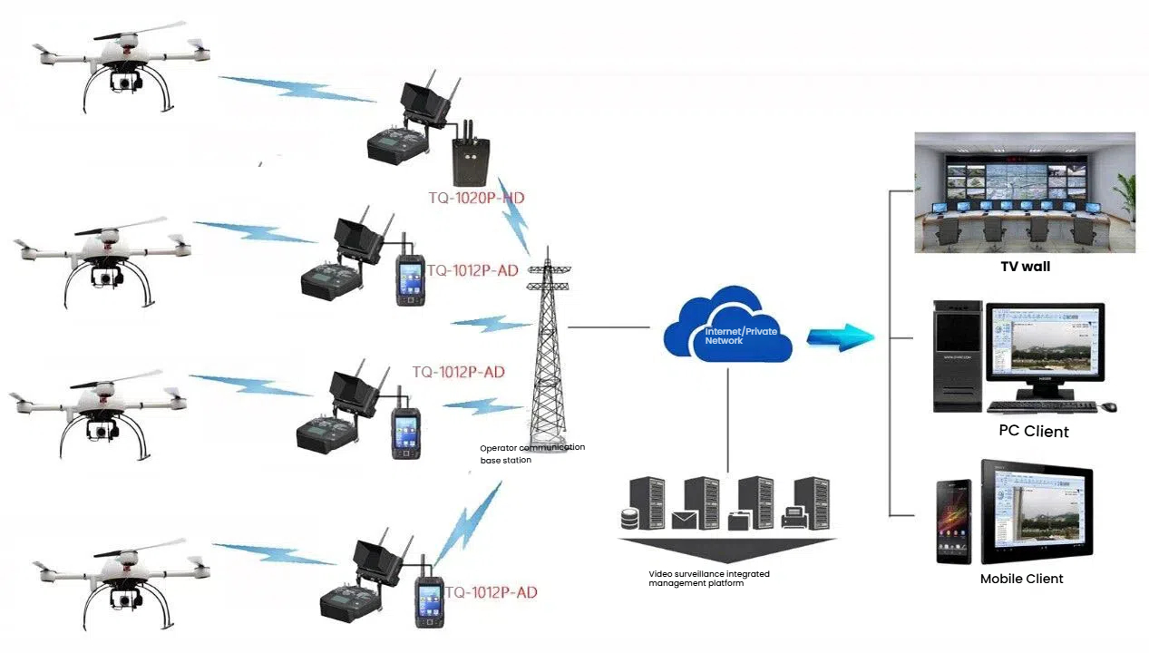
Based on these requirements, the wireless monitoring solution is structured into multiple components in the system architecture. The shore-based center serves as the core hub of the entire marine law enforcement wireless monitoring system, equipped with high-performance servers, data storage devices, and monitoring management software. The servers are responsible for centralized processing, storage, and analysis of the system's data, while the monitoring management software provides law enforcement officers with an intuitive and convenient operation interface, enabling remote control of all monitoring devices, real-time video viewing, data statistical analysis, and other functions. Through the large-screen display system, law enforcement officers can clearly grasp information such as the distribution of fishing vessels and law enforcement dynamics within the entire monitoring area, providing strong support for decision-making. The law enforcement vessels, as the main force of maritime law enforcement, are equipped with infinite ad hoc network devices, high-definition surveillance cameras, AIS (Automatic Identification System) devices, and communication equipment. The ad hoc network devices enable the law enforcement vessels to quickly establish communication connections with the shore-based center, other law enforcement vessels, and surrounding monitoring nodes, achieving real-time data transmission. The high-definition surveillance cameras can conduct all-round and multi-angle monitoring of the surrounding sea areas of the law enforcement vessels, capturing the fishing vessels' operational behaviors. The AIS devices are used to identify and track the information of surrounding vessels, including names, ports of registry, and navigation trajectories, providing important reference for law enforcement officers. The communication equipment ensures that law enforcement officers can conduct voice calls with the command center and other personnel, facilitating timely communication of law enforcement situations. Drones have unique advantages in marine law enforcement monitoring and can achieve high-altitude overview and rapid reconnaissance. On the drones, self-ad hoc network devices, high-definition cameras, and infrared thermal imaging devices are installed. The self-ad hoc network devices ensure the smooth communication between the drones and other nodes, enabling real-time transmission of high-definition videos and images back to the law enforcement vessels or the shore-based center. The high-definition cameras can clearly capture large areas of the sea during the day, detecting suspicious fishing vessels; the infrared thermal imaging device can detect hidden fishing vessels in darkness or adverse weather conditions by sensing the infrared radiation emitted by objects, significantly improving the efficiency and accuracy of law enforcement monitoring. In some key monitoring areas, such as no-fishing zones and fishery resource protection zones, a certain number of floating node devices are deployed. The floating node devices are equipped with self-ad hoc network devices, solar power supply systems, water quality monitoring sensors, and video surveillance equipment. The self-ad hoc network devices transmit the data collected by the floating nodes to other nodes for data sharing. The solar power supply system ensures that the floating nodes can operate stably at sea for a long time without frequent power replacements. The water quality monitoring sensors can monitor various indicators such as temperature, salinity, and pH of the seawater, providing environmental data support for fishery resource protection. The video surveillance equipment conducts real-time monitoring of the surrounding sea areas of the floating nodes, promptly detecting abnormal situations.
In terms of equipment selection and deployment, the infinite ad hoc network devices should choose products that support multiple frequency bands, high bandwidth, and have strong anti-interference capabilities. For example, a certain brand of ad hoc network radio can have its working frequency band adjusted flexibly within the range of 1.0-1.5G, which can adapt to complex electromagnetic environments; the maximum data throughput can reach 80Mbps, which can meet the transmission requirements of high-definition videos and other large data volumes; it adopts advanced COFDM and transmit-receive diversity technologies, with high receiving sensitivity, and can achieve 120km ground-to-air / air-to-air line-of-sight communication and 15km ground-to-ground line-of-sight communication under 2W transmission power, maintaining stable communication connections even in complex environments such as buildings, bushes, hills, and valleys. On the law enforcement vessel, the ad hoc network devices are installed at the high position of the ship, such as the top of the mast, to obtain a better signal transmission view and ensure smooth communication with other nodes. On the drone, a self-ad hoc network module with a small size, light weight, and low power consumption is selected, which can achieve efficient communication without affecting the flight performance of the drone. The self-ad hoc network devices on the buoy nodes need to have waterproof, salt fog resistance, and corrosion resistance properties to adapt to harsh marine environments. They can be installed in the sealed compartment of the buoy and enhance signal reception and transmission capabilities through an external antenna. In terms of surveillance cameras, high-definition network cameras are selected on the law enforcement vessel and buoy nodes, with features such as day-night switching, wide dynamic range, and waterproof and dustproof performance. For example, a certain brand of high-definition camera can have a resolution of 4K, which can clearly capture details of fishing boats; it supports infrared night vision function, providing clear monitoring images at night; the wide dynamic range ensures that the image remains clear in strong light and backlight conditions. The cameras on the drone, in addition to having high-definition shooting capabilities, also need to have anti-shake function to cope with the vibrations during drone flight, ensuring the stability of the shooting image. During deployment, the cameras on the law enforcement vessel should be installed on a 360-degree rotating mount to achieve all-round monitoring; the cameras on the buoy nodes should be installed on the top of the buoy and facing the key monitoring direction; the cameras on the drone should adjust the shooting angle and direction according to its flight mission and monitoring requirements. At the same time, AIS equipment should be equipped for the law enforcement vessel and all vessels within the monitoring range. The AIS equipment can automatically transmit the identification code, name, location, heading, speed, etc. of the vessel, and receive similar information from surrounding vessels. Law enforcement officers can use the AIS system to obtain real-time dynamic information of the vessels and quickly identify suspicious targets. On the law enforcement vessel, the AIS equipment should be integrated with the ad hoc network devices and monitoring system to enable the integration and display of AIS information with other monitoring data, facilitating comprehensive analysis by law enforcement officers. The AIS equipment on the fishing vessels should be installed and used in accordance with relevant regulations to ensure accurate and timely transmission of information. In terms of communication equipment, the law enforcement vessel is equipped with satellite phones and VHF radios as backup communication means. The satellite phone can ensure smooth emergency communication between the law enforcement vessel and the shore-based center in case of interrupted ad hoc network communication or poor signal quality, suitable for long-distance and cross-regional communication needs. The VHF radio is used for short-range communication between vessels, facilitating communication and coordination among law enforcement vessels in some local law enforcement actions. At the same time, handheld walkie-talkies are provided for law enforcement officers to facilitate internal communication on the law enforcement vessel and during boarding inspections. During deployment, satellite phones and VHF radios should be installed in an easily operable position in the cockpit, while handheld walkie-talkies should be carried by the law enforcement officers.
In terms of data transmission and processing, the system adopts a data transmission method combining wireless ad hoc networks and satellite communication. In areas where the ad hoc network signal coverage is good, such as near-sea areas and within the range where effective connections can be maintained between each node, the ad hoc network is given priority for data transmission. The ad hoc network, with its high bandwidth and low latency advantages, can achieve the rapid transmission of large amounts of data such as high-definition videos and real-time location information. When law enforcement vessels or other equipment enter the far-sea areas where the ad hoc network signal cannot cover, it automatically switches to the satellite communication mode. Although satellite communication has higher costs and relatively limited bandwidth, it can ensure the continuity of communication and transfer critical data back to the shore-based center. During the data transmission process, advanced encryption algorithms, such as AES-256 encryption technology, are used to encrypt the data to prevent data theft or tampering, ensuring the security of data transmission. The servers at the shore-based center process and analyze the received data. By using big data analysis technology, a large amount of fishing vessel location information, operation data, and monitoring videos are mined and analyzed to extract valuable information. For example, by analyzing the navigation trajectories and operation times of fishing vessels, it is possible to determine whether they are engaged in illegal fishing activities; for the monitoring videos, intelligent analysis is conducted to automatically identify the type of fishing vessel, the use of fishing gear, etc. At the same time, the processed data is stored in large-capacity data storage devices and a fishery law enforcement database is established to provide data support for subsequent law enforcement decisions, statistical analysis, and case tracing. In addition, through data visualization technology, the analysis results are presented in intuitive charts, maps, and other forms on the operation interface of the monitoring management software, making it convenient for law enforcement officers to view and understand.
The software system is highly functional and provides real-time monitoring capabilities. Law enforcement officers can use the monitoring management software to view the surveillance video footage collected by equipment such as law enforcement vessels, unmanned aircraft, and buoys in real time. The video footage supports multi-window display and can simultaneously monitor multiple areas. In the video playback interface, functions such as video playback, pause, and fast forward are provided to facilitate law enforcement officers in reviewing and analyzing important events. At the same time, the video footage can be zoomed in, zoomed out, and rotated to observe details more clearly. In the target tracking function, the system can automatically track suspicious fishing vessels based on the vessel information provided by the AIS equipment and the target recognition results in the surveillance video. On the electronic map, the position, course, and speed of the target fishing vessel are displayed in real time, and the historical navigation trajectory of the target fishing vessel can be viewed through the trajectory playback function. When the target fishing vessel exhibits abnormal behavior, such as entering prohibited fishing areas or suddenly changing course, the system automatically issues an alert to remind law enforcement officers to pay attention. The data analysis function can comprehensively analyze the collected various data and generate reports such as the distribution of fishery resources, fishing vessel operation patterns, and statistics of illegal fishing behaviors. Through data analysis, scientific basis is provided for the formulation of fishery resource protection policies and the deployment of law enforcement actions. For example, by analyzing the number of illegal fishing cases in various regions over a period of time, key areas for law enforcement can be determined; based on the seasonal changes in fishery resources, monitoring strategies can be adjusted reasonably. The command and dispatch function enables law enforcement officers at the command center to remotely command and dispatch equipment such as law enforcement vessels and unmanned aircraft through the monitoring management software. Task instructions can be issued, such as patrolling a designated area or tracking a specific target; the positions and status of each law enforcement force can be understood in real time, and resources can be rationally allocated to achieve efficient collaborative law enforcement. At the same time, a voice communication function is supported to facilitate direct communication between command personnel and law enforcement personnel at the scene. The user management function manages the permissions of users using the monitoring system, with different levels of users having different operation permissions. For example, senior administrators can make comprehensive settings and management of the system, including adding, deleting, and allocating user permissions; ordinary law enforcement officers can only perform basic operations such as real-time monitoring and viewing data reports. Through strict user management, the security and confidentiality of the system are ensured.
The implementation of the plan is divided into several steps. In the early stage of research and planning, detailed investigations and analyses need to be conducted on the geographical environment, marine meteorological conditions, and existing communication infrastructure of the fishing law enforcement areas. Understand the signal coverage conditions, wind and wave sizes, and ocean current directions in different sea areas, etc., to provide a basis for equipment selection and deployment. For example, in some sea areas frequently affected by strong winds and heavy rain, equipment with stronger protection performance and anti-interference ability should be selected. At the same time, communicate fully with the fishing law enforcement department to clarify their law enforcement procedures, monitoring requirements, and expectations for the system functions. Based on the law enforcement needs, formulate a detailed system planning scheme, including the quantity, type, deployment location of equipment, and the design of software system functional modules. For example, if the law enforcement department has higher requirements for monitoring in specific fishing resource protection areas, then appropriately increase the density of buoy nodes and monitoring equipment in that area. Also, conduct a cost-benefit analysis to evaluate the feasibility of the plan. Consider various costs such as equipment procurement, installation and commissioning, later maintenance, and communication expenses, and combine the expected improvement in law enforcement effectiveness and the benefits of fishery resource protection to determine whether the plan is economically reasonable. For example, by comparing the prices and performance of different brands and models of equipment, choose the most cost-effective equipment while ensuring the system functions. During the equipment procurement and installation stage, purchase the required infinite ad hoc network equipment, monitoring cameras, AIS equipment, communication equipment, etc. based on the previous planning scheme. Choose suppliers with good reputation, reliable product quality, and satisfactory after-sales service. During the procurement process, strictly control the technical parameters and quality standards of the equipment to ensure that the purchased equipment meets the actual needs of fishing law enforcement. For example, conduct strict tests and verifications on parameters such as transmission distance, bandwidth, and anti-interference ability of the ad hoc network equipment. Install the equipment in the law enforcement vessels, unmanned aircraft, buoys, and shore-based centers according to the installation requirements and deployment plans. The equipment installation on the law enforcement vessels needs to consider the vessel structure and navigation safety, ensuring that the equipment is installed firmly and does not affect the normal operation of the vessel. The installation of unmanned aircraft equipment should pay attention to weight balance and flight stability to avoid adverse effects on the flight performance of the unmanned aircraft. The installation of buoy equipment should ensure its stability and waterproofness in harsh marine environments. The equipment installation at the shore-based center should follow the construction specifications of the machine room to ensure a good operating environment for the equipment. During the installation process, carry out equipment debugging to ensure normal operation. Also, during the installation process, provide equipment operation training for law enforcement personnel to familiarize them with the basic functions and operation methods of the equipment. The training content includes connecting and configuring ad hoc network equipment, adjusting the parameters of monitoring cameras, viewing and setting information of AIS equipment, etc. Through on-site demonstrations and practical operation exercises, law enforcement personnel can quickly master the use skills of the equipment, preparing for subsequent law enforcement work. In the system debugging and optimization stage, after the equipment installation is completed, conduct a comprehensive debugging of the entire wireless monitoring system. Check whether the communication connections between each device are normal, whether the data transmission is stable and accurate. Test the various functions of the system through simulation of different law enforcement scenarios, such as the law enforcement vessel traveling in different sea areas, unmanned aircraft conducting flight reconnaissance, and buoy nodes collecting data, to ensure that the system functions normally. For example, simulate a law enforcement vessel discovering suspicious fishing vessels in the open sea area, test whether the system can transmit monitoring videos and location information back to the shore-based center in real time and trigger the alarm function. Based on the problems found during the debugging process, optimize and adjust the system. Such as adjusting the deployment location of equipment, optimizing the routing algorithm of the ad hoc network, and improving the functions of the software system. Ensure that the system can adapt to complex marine environments and meet the actual needs of fishing law enforcement. For instance, if it is found that the signal transmission in a certain area is unstable, the number of self-organizing network nodes can be increased or the positions of the nodes can be adjusted to enhance the signal coverage. After the system is officially put into use, a complete operation and maintenance mechanism will be established. Regular inspections, maintenance, and servicing of the equipment will be carried out, and aging or damaged equipment components will be replaced in a timely manner to ensure the normal operation of the equipment. At the same time, professional technicians will conduct real-time monitoring of the system to promptly detect and solve faults that occur during the system operation. For example, the solar power supply system of the floating node will be checked regularly to ensure sufficient power; performance tests will be conducted on the self-organizing network equipment on the law enforcement vessel to ensure the communication quality. In addition, the system will be upgraded and expanded according to changes in the needs of fishery law enforcement and the development of technology. Such as adding new monitoring equipment and expanding the functional modules of the system, so that the system always maintains an advanced technical level and better serves the fishery law enforcement work.