


Forest Fire Prevention Wireless Monitoring Solution in a County of Jiangxi Province
Forests are one of the important sources of oxygen on Earth. The survival of the vast majority of living creatures on the planet depends on forests. Besides providing basic oxygen supply, they can also provide timber. In terms of maintaining soil and water conservation, stabilizing the ecosystem and maintaining biodiversity, forests are also indispensable.
It's hard to imagine what kind of impact a crisis in the forest would have on the current ecology, environment, and human society.
Among these, the greatest threat to forests is forest fires. Forest fires are highly unpredictable and destructive. Once they lose human control, rescue and handling become extremely difficult, and they are regarded as a global problem.
The causes of forest fires can mainly be classified into two categories: man-made fires and natural fires.
(1) Man-made fires include the following types:
1. Productive fire sources: Fires used in agricultural, forestry and animal husbandry production, fires used in sideline forestry production, fires used in industrial and mining transportation production, etc.
2. Non-productive fire sources: such as smoke from outdoor cooking, cooking activities, burning of paper, heating, etc.
3. Intentional arson: Burning hay, setting off firecrackers and fireworks, etc.
Among human-caused fires, forest fires caused by land clearing and burning, as well as smoking, are the most common. In China's forest fires, the fires caused by smoke from cooking, burning fields, and burning paper at graves account for the majority.
(2) Natural fires: These include lightning fires and spontaneous combustion. Forest fires caused by natural causes account for approximately 1% of all forest fires in our country.
If proper precautions can be taken in the early stage of a forest fire and a prompt response is made upon its occurrence, controlling the fire at its source can significantly reduce the damage caused by the fire.
Therefore, monitoring and early warning have become the key means for forest fire prevention.
User Requirement Analysis
The forestry bureau of a certain county in Jiangxi Province needs to conduct fire monitoring in the forest area under its management. Several characteristic points will be equipped with long-range infrared video equipment to prevent forest fires and avoid uncontrollable losses.
The area is as shown in the following picture:
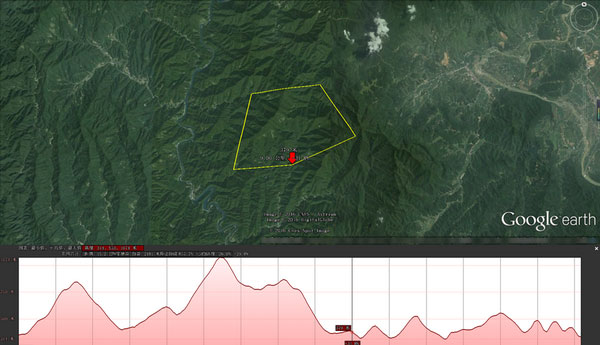
As can be seen from the figure, this area has a significant altitude difference and an irregular terrain. If the traditional wiring method is adopted, it will be an extremely costly project. Moreover, the wiring method itself may pose a fire hazard to the forest. If a forest fire is triggered due to the monitoring process, it will be a waste of resources.
User Solution Design and Thinking
In view of the user's current specific environment, a real-time video transmission system based on wireless bridge transmission needs to be established in this area. This system can be powered by solar and wind energy and can operate normally without connecting to the conventional power grid. This way, it can minimize the fire hazards brought by the video system to the forest to the greatest extent.
This system not only can transmit the video information collected by the destination device to the designated location, but also can simultaneously carry the control signals of the auxiliary devices.
When designing the wireless solution, the following system design principles should be followed: This design mainly adheres to the two main lines of "high quality" and "low cost" for the design. It also comprehensively considers factors such as construction, maintenance and operation, and leaves room for expansion for future development, additional level maintenance, etc. The design content of this system is systematic, complete and comprehensive; the design scheme is scientific, reasonable and operable.
Discussion on the Implementation of the Specific Plan
In this plan, it is divided into two parts. The first part mainly involves using digital wireless equipment at the monitoring points in the mountains and forests to collect data, which is then aggregated at the highest point of the mountain and forest area. The second part is to remotely transmit the monitoring videos of the mountain and forest area via wireless equipment to the forest fire prevention monitoring center.
As shown below:
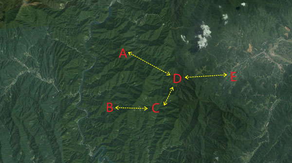
Point E is the forest fire prevention monitoring center, while D is the highest point and monitoring point in the area. Points A, B, and C are other monitoring points.
Points A and D transmit video data via TQ-5040G.
B, C, and D points use the TQ-5017CH wireless bridge for video data transmission.
The video data from point D to point E is transmitted via TQ-5823WJ. This ensures the transmission distance while guaranteeing the sufficiency of the video bandwidth.
The wireless bridge devices at each node of this scheme can accommodate the connection of new devices, facilitating customers to set up new monitoring points.
Wireless transmission equipment topology diagram at the scene:

